


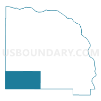
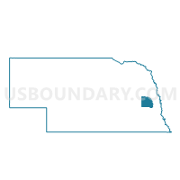
Valparaiso Precinct, Saunders County, Nebraska
About
Outline

Summary
| Unique Area Identifier | 613886 |
| Name | Valparaiso Precinct |
| County | Saunders County |
| State | Nebraska |
| Area (square miles) | 72.18 |
| Land Area (square miles) | 71.93 |
| Water Area (square miles) | 0.25 |
| % of Land Area | 99.65 |
| % of Water Area | 0.35 |
| Latitude of the Internal Point | 41.09679350 |
| Longtitude of the Internal Point | -96.78395550 |
Maps

Graphs
Select a template below for downloading or customizing gragh for Valparaiso Precinct, Saunders County, Nebraska


Neighbors
Neighoring Voting District (by Name) Neighboring Voting District on the Map
- Ceresco Precinct, Saunders County, NE
- Oak Creek Precinct, Butler County, NE
- Richardson Precinct, Butler County, NE
- Rock Creek Precinct, Lancaster County, NE
- Wahoo Rural Precinct, Saunders County, NE
- West Salt Precinct, Lancaster County, NE
- Weston Precinct, Saunders County, NE
Top 10 Neighboring County Subdivision (by Population) Neighboring County Subdivision on the Map
- Richland township, Saunders County, NE (1,320)
- Oak Creek township, Saunders County, NE (940)
- Little Salt precinct, Lancaster County, NE (859)
- Chapman township, Saunders County, NE (604)
- Rock Creek precinct, Lancaster County, NE (582)
- Oak Creek township, Butler County, NE (500)
- Stocking township, Saunders County, NE (453)
- West Oak precinct, Lancaster County, NE (427)
- Richardson township, Butler County, NE (424)
- Rock Creek township, Saunders County, NE (317)
Top 10 Neighboring Place (by Population) Neighboring Place on the Map
Top 10 Neighboring Unified School District (by Population) Neighboring Unified School District on the Map
- Wahoo Public Schools, NE (7,198)
- Raymond Central Schools, NE (4,375)
- East Butler Public Schools, NE (1,902)
Top 10 Neighboring State Legislative District Upper Chamber (by Population) Neighboring State Legislative District Upper Chamber on the Map
- State Senate District 25, NE (48,973)
- State Senate District 21, NE (44,532)
- State Senate District 23, NE (40,859)
Top 10 Neighboring 111th Congressional District (by Population) Neighboring 111th Congressional District on the Map
Top 10 Neighboring Census Tract (by Population) Neighboring Census Tract on the Map
- Census Tract 101, Lancaster County, NE (6,030)
- Census Tract 9682, Saunders County, NE (5,485)
- Census Tract 102.02, Lancaster County, NE (4,388)
- Census Tract 9678, Butler County, NE (1,958)
Top 10 Neighboring 5-Digit ZIP Code Tabulation Area (by Population) Neighboring 5-Digit ZIP Code Tabulation Area on the Map
- 68066, NE (5,640)
- 68017, NE (1,692)
- 68065, NE (1,510)
- 68070, NE (836)
- 68626, NE (614)
- 68635, NE (491)